This month (June 2023) is the 20th anniversary of opening of BART SFO extension. Millbrae is the end of the line of this extension & the transfer point between Caltrain and BART. The station was built with an expectation of high ridership & transfer activities, but things changed quite a bit over the past 20 years with changes in economy, transportation/housing priorities, and COVID.
2003
20 years ago I was a young transit activist & a regular Caltrain rider. I was able to see the station being constructed and was there on the opening day.
Over the weekend, VTA’s PR team has been promoting the agency’s new bus network that is redesigned around the new BART stations that have yet to open due to numerous construction related delays. Part of the redesign also involved elimination or service reductions of unproductive routes. One of those routes eliminated is the Almaden light rail branch.
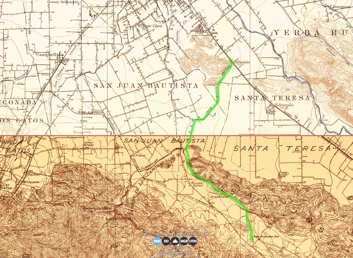
The light rail branch was constructed with the southern portion of the Guadalupe main line in the early 1990s. That right of way is part of a former rail spur coming off of what currently is the Caltrain mainline on Monterey Highway. That spur line went all the way down the Almaden Valley. There was another spur line coming off what is currently the Vasona light rail line, following down the path of what is currently Camden Avenue. Those spur lines were built to serve the mercury mines in the valley, as well as the Almaden Winery.
Highlighted is the original rail spur, as recorded on the USGS maps from 1889 (above) and 1916 (below)
The southern portion of the line (south of Almaden station) was closed around 1930s due to closure of the mines, but rail traffic continued on the rest of the spur up to and through the 1970s and it was formally abandoned in 1981.
1950s USGS maps
After the closure the rail spur has been included in the planning for transit on the Gaudalupe corridor (Highway 87). In a 1981 study, planners proposed a light rail alternative, along with other alternatives such as bus lanes on expressway or freeway. The light rail alternative was chosen and built along with a new freeway. The initial light rail alignment on North 1st Street was opened in 1987. The rest of the light rail in downtown San Jose and South San Jose was opened in the latter years until completion in 1991. At the same time, Caltrain service was extended from San Jose Cahill Street to Tamien to connect with the light rail.
The present State Route 85 and 87 rights-of-way that comprise much of the Guadalupe Corridor have been designated for proposed freeways since the 1950s and 1960s. The state and county purchased a large amount of property within the designated rights-of-way. Pursuant to the freeway designation, title to all property purchased by the county was transferred to CALTRANS ownership in July, 1970. By 1972, right-of-way purchasing was suspended due to lack of funding and the implementation of new environmental legislation…
Planning for mass transportation in Santa Clara County began in earnest in 1974 with the “Rapid Transit Development Project”. The County Transit District contracted a study to investigate alternative transit system technologies, delineate high ridership demand corridors, and identify the financial costs and environmental, social and economic impacts of large scale rapid transit systems capable of attracting 30 percent of all daily person trips made in the County.
Guadalupe Corridor Transportation Project, Santa Clara County: Environmental Impact Statement
The idea of the corridor was to bring commuters from the bedroom suburbs in South San Jose to the suburban office parks of early Silicon Valley up north, and turn Downtown San Jose into a shopping and entertainment destination. The downtown’s Fairmont Hotel and Convention Center were all built with the support of the city’s redevelopment agency in the late 1980s. The city tried hard to put a shopping mall in downtown, but that “Pavilion” mall didn’t last very long.
The Almaden branch had always been operated as a shuttle route from Ohlone/Chynoweth with a single light rail car. While the service provided was efficient and frequent (every 10 minutes back in the day), ridership had always been poor for many reasons. In numerous times VTA proposed to end the Alamden service, first in 2003 (when it proposed a 21% service cut) and 2009. Both times the line was saved but not this time.
To check out the situation, I spent a half-hour riding the shuttle one recent afternoon. It was mostly empty, though we had a brief moment of excitement when eight people — two couples, three teens and an old man — got on at Oakridge station.
Scott Herhold – June 2009, A little rail line in jeopardy
In 2009, VTA thought about integrating the Almaden branch into mainline service, which could help boost ridership. However lack of funding, and lack of a staging/turnback facility (pocket track) in downtown basically put the idea off the table. VTA did implement express LRT (as extra trips from Santa Teresa to Baypointe) in 2010 but discontinued in 2018.
This time VTA decided to kill this route after a more methodological approach was taken to redraw the network, which helped brought politicians to come to terms of whether to keep or kill the service, and also without express intention to massively reduce overall service, but rather to reallocate service hours where there’s more ridership potential. Transit service will still be available along this route, but it would be with a bus (as part of a longer route from Downtown) at a 30 minute headway.
On one hand, while there’s no dispute that this line had terrible ridership, cutting this line is no way progress, because we remember back in the day when streetcar lines were discontinued in San Jose and across the country and buses were promoted as a superior substitute when they were not.
San Jose has the dubious honor of being the first US city to close one of its' modern light rail lines. The Almaden shuttle had 3 stops, one of which remains open as a stop on one of the other VTA light rail lines. https://t.co/0pb7gZrss5
On the other hand, there are no easy solutions to save this line. Being in the suburbs, riders can easily access Ohlone/Chynoweth and board the main line there directly. Plenty of parking is available at that stop. Ohlone/Chynoweth is also within a short biking (and scootering as I did on the final night) distance away from other stops. The increasing wealth and access to automobiles in the community also negatively impact ridership. The line lacks captive destinations (like airports, universities, or stadia) where parking is expensive and people have a financial incentive to take transit. Suburban malls like Oakridge have free parking and that mall is not anywhere unique enough for people from outside of South San Jose to take light rail and shop there.
Another factor not well mentioned is that, VTA, like many transit agencies throughout the Bay Area and beyond, has an operator shortage. In the last day of the Almaden line, VTA had cancelled a trip on the blue line during peak hours, turning a 15 minute wait into a 30 minute wait.
Throughout the 2000s VTA used these lcons to represent light rail lines. The icon of orange grapes represented the Almaden line, which was supposed to pay homage to the old Almaden Winery. I guess this is time to get some boxed Almaden wine to celebrate the end of a decade now. Cheers.
BART’s only standard gauge line between Pittsburg and Antioch is set to open sometime in May of this year. Given my long time advocacy (2 decades!) for standard rail over BART this is the only BART extension that I look forward to.
For many decades, there’s been a struggle between expanding BART versus expanding a standard gauge rail line like Caltrain in the Bay Area. BART’s hardware is unique and designed to work as an urban metro system (and also carries a high price tag). Caltrain’s hardware is off-the-shelf and designed for the suburban/regional environment. The expansions in question, whether it is to SFO or San Jose, is largely suburban and regional.
Some think that BART’s wide gauge custom design ought to be the only standard for regional transit in the Bay Area, as envisioned in the 1950s. They’ve been pushing BART around the Bay and BART replacing Caltrain. They think that other rail technologies somehow wouldn’t be capable to do what BART does. They would tell you that if you want trains every 15 minutes all day on the Peninsula, replace Caltrain by extending BART.
On the other hand many regions in the United States and beyond have trains that have different physical characteristics but operated by the same agency and even under the same brand. They often feature integrated fares and coordinated scheduling. In Los Angeles and Boston, lines that have color designations include urban metro lines, light rail lines, and bus routes (with dedicated bus ways). Systems in Seattle, Denver, and Salt Lake City operate the commuter rail and light rail. In case of Denver, the commuter rail and light rail are both electric, operate at high frequency, and share the same regional zone fare structure. So basically the branding of the train doesn’t require that they all have the same physical characteristics. If a Caltrain or a SMART train has BART logos and operate as frequent as BART, then they’re BART.
New for this year is an interactive Muni map that I spent a couple of weeks to produce. I want some kind of mobile friendly interactive map for the web site but with limited choices it is better for me to create one. It is displayed on Google’s API so you can switch to other standard Google layers and even have street views. It is also designed to be printed as well. It includes some of the most recent changes like the 5L, two way Haight St and left turn for 29.