Difference between revisions of "UTA S-Line"
m (Text replace - "http://www.transitunlimited.org" to "https://www.transit.wiki") |
m (Text replacement - "|format=googlemaps" to "|format=googlemaps|scrollwheelzoom=yes") |
||
| (11 intermediate revisions by 2 users not shown) | |||
| Line 1: | Line 1: | ||
| − | [[File:Utasline.jpg| | + | [[File:Utasline.jpg|300px|right]] [[File:23094737075_5102240416_z.jpg|300px|right]] |
{{Routeinfo | {{Routeinfo | ||
| − | | letter = S-Line | + | |provider=UTA |
| − | | to = Sugar House Streetcar | + | |letter=S-Line |
| + | |type=rail | ||
| + | |to=Sugar House Streetcar: Sugar House - Central Pointe | ||
}} | }} | ||
{{Schedulelinksimple | {{Schedulelinksimple | ||
|link=http://www.rideuta.com/mc/?page=Bus-BusHome-Route720 | |link=http://www.rideuta.com/mc/?page=Bus-BusHome-Route720 | ||
}} | }} | ||
| − | |||
| − | + | Streetcar runs every 15 minutes weekdays and 20 minutes weekends and holidays throughout the day. Pay fare at a [[UTA ticket machine]] on the platform before boarding streetcar. Streetcar connects with [[UTA TRAX]] trains at Central Pointe Station. | |
| − | The line | + | The line features low floor streetcars. Riders in wheelchair or other mobility device can board through any of the two center doors. Push the blue button on the train door to open the door and deploy the boarding ramp. |
| − | The | + | Bicyclists may board through the two center doors. Bikes should be stored at the designated spots located towards the center of the car. Bicycles must not block doors, aisles or stairways on the car. No fuel powered vehicles are allowed. |
| + | |||
| + | The line operates as a single track line with a passing track at the 500 E station, where the two trains meet to pass, and at the Sugarhouse station. The line uses the same S-70 model rail car as on TRAX, except that S-line cars operate as single cars with couplers covered up. The maximum speed is reduced from 65 mph to 25 mph. | ||
| + | |||
| + | The corridor features Parley's Trail, which will eventually stretch 8.25 miles from the Jordan River Parkway in the west to the Bonneville Shoreline trail at I-215/I-80 in the east. The segment between Central Pointe and Sugarhouse is known together as the S Line Greenway. | ||
| − | |||
{{col1|35%}} | {{col1|35%}} | ||
==Route and stops== | ==Route and stops== | ||
<div style="width:100%;overflow:auto"> | <div style="width:100%;overflow:auto"> | ||
{{RMtop}} | {{RMtop}} | ||
| − | {{RM|Sl=exCONTg|Tl=''' | + | {{RM|Sl=exCONTg|Tl='''Stops'''|Tr='''Points of interest'''}} |
| − | {{RM|Sl=exBHF-L|Sc= | + | {{RM|Sl=exBHF-L|Sc=uKBHFa-R|Tl={{stn|Central Pointe}}|Tr={{TRAXlines|red}} {{TRAXlines|green}} {{TRAXlines|blue}}}} |
{{RM|Sl=exCONTf|Sc=uSTR}} | {{RM|Sl=exCONTf|Sc=uSTR}} | ||
| − | {{RM|Sc= | + | {{RM|Sc=uHST|Tl={{Stop/SR|40.72230, -111.88825|South Salt Lake|South Salt Lake City}}|Tr=[[Winnco]]}} |
| − | {{RM|Sc= | + | {{RM|Sc=uSTR|Tl=|Tr=}} |
| − | {{RM|Sc= | + | {{RM|Sc=uHST|Tl={{Stop/SR|40.72232, -111.88258|South Salt Lake|300 E}}}} |
| − | {{RM|Sc= | + | {{RM|Sc=uSTR|Tl=|Tr=}} |
| − | {{RM|Sc= | + | {{RM|Sc=uHST|Tl={{Stop/SR|40.72231, -111.87683|South Salt Lake|500 E}}}} |
| − | {{RM|Sc= | + | {{RM|Sc=uSTR|Tl=|Tr=}} |
| + | {{RM|Sc=uHST|Tl={{Stop/SR|40.72268, -111.87248|Salt Lake City|700 E}}}} | ||
| + | {{RM|Sc=uSTR|Tl=|Tr=}} | ||
| + | {{RM|Sc=uHST|Tl={{Stop/SR|40.72276, -111.86573|Salt Lake City|Sugarmont}}|Tr=[[Sugar House]]}} | ||
| + | {{RM|Sc=uSTR|Tl=|Tr=}} | ||
| + | {{RM|Sc=uKHSTe|Tl={{Stop/SR|40.722771, -111.861721|Salt Lake City|Fairmont}}|Tr=[[Sugar House Shopping Center]]}} | ||
| + | {{RM|Sc-uSTR|T1=|Tr=[[Fairmont Park & Aquatic Center]]}} | ||
| + | {{RM|Sc-uSTR|T1=|Tr=[[Westminster College]]}} | ||
|} | |} | ||
</div> | </div> | ||
| − | {{col2| | + | {{col2|63%}} |
| + | |||
==Map== | ==Map== | ||
<div class=bigmap> | <div class=bigmap> | ||
| − | {{#compound_query: [[-Street rail::UTA S-Line]] [[Category:Points of interest]] | + | {{#compound_query: [[-Street rail::UTA S-Line]] [[Category:Points of interest]];icon=Mm_20_red.png |
| − | | [[Served by::UTA S-Line]];icon= | + | | [[Served by::UTA S-Line]];icon=Modernstreetcaricon.png;?latlong;?Rname|format=googlemaps|scrollwheelzoom=yes|width=100%|height=100%|limit=500|showtitle=no|template=liststn2 |
|gkml=https://www.transit.wiki/images/c/c1/Utatrax.kml|lines={{#show: {{PAGENAME}}| ?line|sep=;}} | |gkml=https://www.transit.wiki/images/c/c1/Utatrax.kml|lines={{#show: {{PAGENAME}}| ?line|sep=;}} | ||
}} | }} | ||
Latest revision as of 15:26, 25 December 2019
Streetcar runs every 15 minutes weekdays and 20 minutes weekends and holidays throughout the day. Pay fare at a UTA ticket machine on the platform before boarding streetcar. Streetcar connects with UTA TRAX trains at Central Pointe Station.
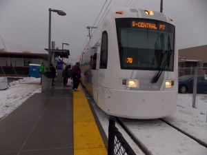
The line features low floor streetcars. Riders in wheelchair or other mobility device can board through any of the two center doors. Push the blue button on the train door to open the door and deploy the boarding ramp.
Bicyclists may board through the two center doors. Bikes should be stored at the designated spots located towards the center of the car. Bicycles must not block doors, aisles or stairways on the car. No fuel powered vehicles are allowed.
The line operates as a single track line with a passing track at the 500 E station, where the two trains meet to pass, and at the Sugarhouse station. The line uses the same S-70 model rail car as on TRAX, except that S-line cars operate as single cars with couplers covered up. The maximum speed is reduced from 65 mph to 25 mph.
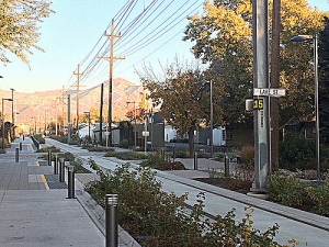
The corridor features Parley's Trail, which will eventually stretch 8.25 miles from the Jordan River Parkway in the west to the Bonneville Shoreline trail at I-215/I-80 in the east. The segment between Central Pointe and Sugarhouse is known together as the S Line Greenway.
Route and stops
| Stops | Points of interest | |||
| Central Pointe | ||||
| South Salt Lake City | Winnco | |||
| 300 E | ||||
| 500 E | ||||
| 700 E | ||||
| Sugarmont | Sugar House | |||
| Fairmont | Sugar House Shopping Center | |||
| Fairmont Park & Aquatic Center | ||||
| Westminster College | ||||
Map


