Difference between revisions of "TM Third Street/Ocean View"
m |
m |
||
| Line 2: | Line 2: | ||
| letter = M | | letter = M | ||
| name = Ocean View | | name = Ocean View | ||
| − | | to = '''Muni Metro:''' | + | | to = '''Muni Metro bus substitution:''' West Portal Station - Balboa Park Station |
}} | }} | ||
<div class="map" align="right"> | <div class="map" align="right"> | ||
| Line 8: | Line 8: | ||
</div> | </div> | ||
| − | + | {{Notice|Due to [ St. Francis Circle rail replacement project. M rail service is replaced by buses between West Portal and Balboa Park Station.}} | |
; Maps | ; Maps | ||
: [http://www.sfmta.com/cms/mmaps/documents/M.pdf Map (PDF)] | [http://www.nextmuni.com/googleMap/googleMap.jsp?a=sf-muni&r=M Live map] | : [http://www.sfmta.com/cms/mmaps/documents/M.pdf Map (PDF)] | [http://www.nextmuni.com/googleMap/googleMap.jsp?a=sf-muni&r=M Live map] | ||
| Line 15: | Line 15: | ||
| − | Inbound means M cars going toward | + | Inbound means M cars going toward West Portal Station. Outbound means M cars going toward Balboa Park. |
| − | |||
| − | |||
| − | == | + | ==Points of interest== |
| − | + | * [[Place::Stern Grove]] | |
| + | * [[Place::Lakeside Village]] | ||
| + | * [[Stonestown Shopping Center]] | ||
| + | * [[San Francisco State University]] | ||
| − | + | ==Connections== | |
| − | + | Buses make curb stops only. | |
| − | + | * [[Rail::West Portal Station]] | |
| − | + | * [[Rail::Stonestown Station]] | |
| − | + | * [[Rail::SF State Station]] | |
| − | + | * [[Rail::Balboa Park Station]] | |
| − | |||
| − | |||
| − | |||
| − | |||
| − | |||
| − | |||
| − | |||
| − | |||
| − | |||
| − | |||
| − | |||
| − | |||
| − | |||
{{Muni routes}} [[Category:Muni Metro routes]] | {{Muni routes}} [[Category:Muni Metro routes]] | ||
Revision as of 00:21, 18 May 2010
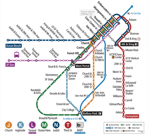
🚍 Muni Metro bus substitution: West Portal Station - Balboa Park Station
Due to [ St. Francis Circle rail replacement project. M rail service is replaced by buses between West Portal and Balboa Park Station.
- Maps
- Map (PDF) | Live map
- Schedules
- Schedules | Frequency guide | Live arrival prediction
Inbound means M cars going toward West Portal Station. Outbound means M cars going toward Balboa Park.
Points of interest
Connections
Buses make curb stops only.

