Difference between revisions of "TM-Third Street/Oceanview"
| Line 7: | Line 7: | ||
| − | [http://www.nextmuni.com/googleMap/googleMap.jsp?a=sf-muni&r=KT Live map] (Combined with K) | | + | ; Maps |
| − | [http://www.sfmta.com/cms/ | + | : [http://www.sfmta.com/cms/mmaps/documents/T.pdf Map (PDF)] | [http://www.nextmuni.com/googleMap/googleMap.jsp?a=sf-muni&r=KT Live map] (Combined with K) |
| + | ; Schedules | ||
| + | : [http://transit.511.org/accessible/schedules/RouteInfo.aspx?cid=SF&rte=26606 Schedules] | [http://www.sfmta.com/cms/asystem/routedesc.php?rted=T Frequency guide] | [http://www.nextmuni.com/predictor/simpleStopSelector.shtml?a=sf-muni&r=KT Live arrival prediction] (Combined with K) | ||
| Line 14: | Line 16: | ||
The T line is interlined with {{MMLNS|K|y}}, which serves the western side of San Francisco. For outbound cars, the signs change from T to K at [[Embarcadero Station]] and continue to [[Balboa Park Station]]. For inbound cars, the signs change from K to T at West Portal Station and continue to [[Sunnydale Station]]. | The T line is interlined with {{MMLNS|K|y}}, which serves the western side of San Francisco. For outbound cars, the signs change from T to K at [[Embarcadero Station]] and continue to [[Balboa Park Station]]. For inbound cars, the signs change from K to T at West Portal Station and continue to [[Sunnydale Station]]. | ||
| − | |||
| − | |||
==Points of interest== | ==Points of interest== | ||
| Line 24: | Line 24: | ||
* [[San Francisco Civic Center]] | * [[San Francisco Civic Center]] | ||
* [[The Castro]] | * [[The Castro]] | ||
| − | |||
| − | |||
| − | |||
| − | |||
| − | |||
| − | |||
| − | |||
| − | |||
| − | |||
==Stop list== | ==Stop list== | ||
Revision as of 11:53, 14 November 2008
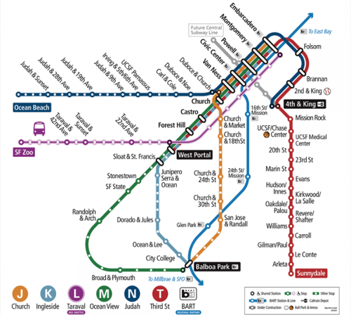
| Muni Metro system map |
|---|
Sunnydale Station - West Portal Station
- Maps
- Map (PDF) | Live map (Combined with K)
- Schedules
- Schedules | Frequency guide | Live arrival prediction (Combined with K)
Inbound means T cars going toward Sunnydale Station. Outbound means T cars going toward West Portal.
The T line is interlined with K Ingleside, which serves the western side of San Francisco. For outbound cars, the signs change from T to K at Embarcadero Station and continue to Balboa Park Station. For inbound cars, the signs change from K to T at West Portal Station and continue to Sunnydale Station.
Points of interest
- San Francisco City College Southeast campus
- UCSF Mission Bay
- AT&T Park
- Downtown San Francisco
- San Francisco Civic Center
- The Castro
Stop list
Only wheelchair accessible stops are shown unless otherwise indicated.
<tab sep=comma cellspacing=0 cellpadding=0>
![]() , Sunnydale Station
, Sunnydale Station
![]() , Arleta Station
, Arleta Station
![]() , Le Conte Station
, Le Conte Station
![]() , Gilman/Paul Station
, Gilman/Paul Station
![]() , Carroll Station
, Carroll Station
![]() , Williams Station
, Williams Station
![]() , Revere/Shafter Station
, Revere/Shafter Station
![]() , Oakdale/Palou Station
, Oakdale/Palou Station
![]() , Kirkwood/La Salle Station
, Kirkwood/La Salle Station
![]() , Hudson/Innes Station
, Hudson/Innes Station
![]() , Evans Station
, Evans Station
![]() , Marin Street Station
, Marin Street Station
![]() , 23rd Street Station
, 23rd Street Station
![]() , 20th Street Station
, 20th Street Station
![]() , Mariposa Station
, Mariposa Station
![]() , UCSF Mission Bay Station
, UCSF Mission Bay Station
![]() , Mission Rock Station
, Mission Rock Station
![]() , 4th and King Station (Caltrain)
, 4th and King Station (Caltrain)
![]() , 2nd and King Station (AT&T Park)
, 2nd and King Station (AT&T Park)
![]() , Brannan Station
, Brannan Station
![]() , Folsom Station
, Folsom Station
![]() , Subway portal - Outbound trains change signs to K Ingleside
, Subway portal - Outbound trains change signs to K Ingleside
![]() , Embarcadero Station
, Embarcadero Station
![]() , Montgomery Station
, Montgomery Station
![]() , Powell Station
, Powell Station
![]() , Civic Center/United Nations Plaza Station
, Civic Center/United Nations Plaza Station
![]() , Van Ness Station
, Van Ness Station
![]() , Church Station
, Church Station
![]() , Castro Station
, Castro Station
![]() , Forest Hill Station
, Forest Hill Station
![]() , West Portal Station
, West Portal Station
![]() , Subway portal - Outbound trains continue to Balboa Park as K Ingleside
</tab>
, Subway portal - Outbound trains continue to Balboa Park as K Ingleside
</tab>

