Difference between revisions of "TM Third Street/Ocean View"
m (Text replace - '* [[Stern' to '* [[Park::Stern') |
m |
||
| Line 18: | Line 18: | ||
From Balboa Park, K operates on surface until West Portal, then continues underground to downtown under Market Street. | From Balboa Park, K operates on surface until West Portal, then continues underground to downtown under Market Street. | ||
| − | |||
| − | |||
| − | |||
| − | |||
| − | |||
| − | |||
| − | |||
| − | |||
| − | |||
==Stop list== | ==Stop list== | ||
| Line 33: | Line 24: | ||
<tab sep=comma cellspacing=0 cellpadding=0> | <tab sep=comma cellspacing=0 cellpadding=0> | ||
[[Image:stnstart.png]], [[Rail::Embarcadero Station]] | [[Image:stnstart.png]], [[Rail::Embarcadero Station]] | ||
| − | [[Image:stn.png]], [[Rail::Montgomery Station]] | + | [[Image:stn.png]], [[Rail::Montgomery Station]], [[Place::Downtown San Francisco]] |
| − | [[Image:stn.png]], [[Rail::Powell Station]] | + | [[Image:stn.png]], [[Rail::Powell Station]], [[Place::Union Square]] |
| − | [[Image:stn.png]], [[Rail::Civic Center Station (San Francisco)|Civic Center Station]] | + | [[Image:stn.png]], [[Rail::Civic Center Station (San Francisco)|Civic Center Station]], [[Place::San Francisco Civic Center|Civic Center]] |
[[Image:stn.png]], [[Rail::Van Ness Station]] | [[Image:stn.png]], [[Rail::Van Ness Station]] | ||
[[Image:stn.png]], [[Rail::Church Station]] | [[Image:stn.png]], [[Rail::Church Station]] | ||
| − | [[Image:stn.png]], [[Rail::Castro Station]] | + | [[Image:stn.png]], [[Rail::Castro Station]], [[Place::The Castro]] |
[[Image:stn.png]], [[Rail::Forest Hill Station]] | [[Image:stn.png]], [[Rail::Forest Hill Station]] | ||
[[Image:stn.png]], [[Rail::West Portal Station]] | [[Image:stn.png]], [[Rail::West Portal Station]] | ||
[[Image:line.png]], ''Subway portal'' | [[Image:line.png]], ''Subway portal'' | ||
| − | [[Image:stop.png]], West Portal and Sloat (St. Francis Circle) | + | [[Image:stop.png]], West Portal and Sloat (St. Francis Circle), [[Park::Stern Grove]] |
| − | [[Image:stn.png]], [[Rail::Stonestown Station]] | + | [[Image:stn.png]], [[Rail::Stonestown Station]], [[Shopping center::Stonestown Shopping Center]] |
| − | [[Image:stn.png]], [[Rail::SF State Station]] | + | [[Image:stn.png]], [[Rail::SF State Station]], [[University::San Francisco State University]] |
[[Image:stop.png]], Randolph and Arch | [[Image:stop.png]], Randolph and Arch | ||
[[Image:stop.png]], Broad and Plymouth | [[Image:stop.png]], Broad and Plymouth | ||
Revision as of 18:15, 1 May 2009
- Maps
- Map (PDF) | Live map
- Schedules
- Schedules | Frequency guide | Live arrival prediction
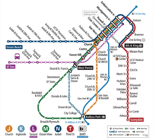
Inbound means M cars going toward Embarcadero Station. Outbound means M cars going toward Balboa Park.
From Balboa Park, K operates on surface until West Portal, then continues underground to downtown under Market Street.
Stop list
Only wheelchair accessible stops are shown unless otherwise indicated.
<tab sep=comma cellspacing=0 cellpadding=0>
![]() , Embarcadero Station
, Embarcadero Station
![]() , Montgomery Station, Downtown San Francisco
, Montgomery Station, Downtown San Francisco
![]() , Powell Station, Union Square
, Powell Station, Union Square
![]() , Civic Center Station, Civic Center
, Civic Center Station, Civic Center
![]() , Van Ness Station
, Van Ness Station
![]() , Church Station
, Church Station
![]() , Castro Station, The Castro
, Castro Station, The Castro
![]() , Forest Hill Station
, Forest Hill Station
![]() , West Portal Station
, West Portal Station
![]() , Subway portal
, Subway portal
![]() , West Portal and Sloat (St. Francis Circle), Stern Grove
, West Portal and Sloat (St. Francis Circle), Stern Grove
![]() , Stonestown Station, Stonestown Shopping Center
, Stonestown Station, Stonestown Shopping Center
![]() , SF State Station, San Francisco State University
, SF State Station, San Francisco State University
![]() , Randolph and Arch
, Randolph and Arch
![]() , Broad and Plymouth
, Broad and Plymouth
![]() , San Jose and Geneva (Balboa Park Station)
</tab>
, San Jose and Geneva (Balboa Park Station)
</tab>

