Difference between revisions of "TM Third Street/Ocean View"
m (→Stop list) |
|||
| Line 34: | Line 34: | ||
align=right| ''Subway portal''; {{ri|linetunnelend}}; | align=right| ''Subway portal''; {{ri|linetunnelend}}; | ||
align=right| {{I-stn|West Portal & 14th|San Francisco|37.737992, -122.469061}}; {{ri|stop}} | align=right| {{I-stn|West Portal & 14th|San Francisco|37.737992, -122.469061}}; {{ri|stop}} | ||
| − | align=right| {{I-stn|St. Francis Circle|37.734777, -122.471528}}; {{ri|stn}}; [[Street rail::St. Francis Circle]] | + | align=right| {{I-stn|St. Francis Circle|San Francisco|37.734777, -122.471528}}; {{ri|stn}}; [[Street rail::St. Francis Circle]] |
align=right| {{I-stn|Ocean & Right Of Way|San Francisco|37.731939, -122.473751}}; {{ri|stop}}; [[Street rail::Lakeside Village]] | align=right| {{I-stn|Ocean & Right Of Way|San Francisco|37.731939, -122.473751}}; {{ri|stop}}; [[Street rail::Lakeside Village]] | ||
align=right| {{I-stn|Right Of Way & Eucalyptus|San Francisco|37.73109, -122.47437}}; {{ri|stop}} | align=right| {{I-stn|Right Of Way & Eucalyptus|San Francisco|37.73109, -122.47437}}; {{ri|stop}} | ||
Revision as of 01:17, 9 October 2012
- Maps
- Map (PDF) | Live map
- Schedules
- Schedules | Frequency guide | Live arrival prediction
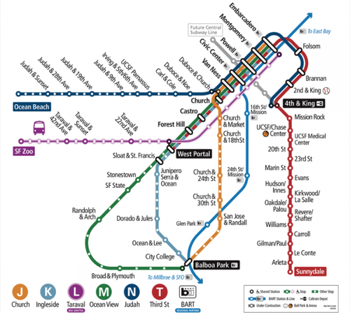
Inbound means M cars going toward Embarcadero Station. Outbound means M cars going toward Balboa Park.
From Balboa Park, K operates on surface until West Portal, then continues underground to downtown under Market Street.
Stop list
Only wheelchair accessible stops are shown unless otherwise indicated.
<simpletable sep=semicolon cellspacing=0 cellpadding=0>
align=right| Stations/stops; ; Points of interest
align=right| Embarcadero Station; ![]() ;
align=right| Montgomery Station;
;
align=right| Montgomery Station; ![]() ; Downtown San Francisco
align=right| Powell Station;
; Downtown San Francisco
align=right| Powell Station; ![]() ; Union Square
align=right| Civic Center Station;
; Union Square
align=right| Civic Center Station; ![]() ; Civic Center
align=right| Van Ness Station;
; Civic Center
align=right| Van Ness Station; ![]() ;
align=right| Church Station;
;
align=right| Church Station; ![]() ;
align=right| Castro Station;
;
align=right| Castro Station; ![]() ; The Castro
align=right| Forest Hill Station;
; The Castro
align=right| Forest Hill Station; ![]() ;
align=right| West Portal Station;
;
align=right| West Portal Station; ![]() ;
align=right| Subway portal;
;
align=right| Subway portal; ![]() ;
align=right| West Portal & 14th;
;
align=right| West Portal & 14th; ![]() align=right| St. Francis CircleA user-defined subobject contained an invalid naming scheme. The dot notation (_St._Francis_Circle) used within the first five characters is reserved for extensions. You may set a named identifier.;
align=right| St. Francis CircleA user-defined subobject contained an invalid naming scheme. The dot notation (_St._Francis_Circle) used within the first five characters is reserved for extensions. You may set a named identifier.; ![]() ; St. Francis Circle
align=right| Ocean & Right Of Way;
; St. Francis Circle
align=right| Ocean & Right Of Way; ![]() ; Lakeside Village
align=right| Right Of Way & Eucalyptus;
; Lakeside Village
align=right| Right Of Way & Eucalyptus; ![]() align=right| Stonestown Station;
align=right| Stonestown Station; ![]() ; Stonestown Galleria
align=right| SF State Station;
; Stonestown Galleria
align=right| SF State Station; ![]() ; SFSU
align=right| 19th & N Randolph/Junipero Serra;
; SFSU
align=right| 19th & N Randolph/Junipero Serra; ![]() ; Parkmerced
align=right| 19th & Randolph;
; Parkmerced
align=right| 19th & Randolph; ![]() ;
align=right| Randolph & Arch;
;
align=right| Randolph & Arch; ![]() ;
align=right| Randolph & Bright;
;
align=right| Randolph & Bright; ![]() ;
align=right| Orizaba & Broad;
;
align=right| Orizaba & Broad; ![]() ;
align=right| Broad & Capitol;
;
align=right| Broad & Capitol; ![]() ;
align=right| Broad & Plymouth;
;
align=right| Broad & Plymouth; ![]() ;
align=right| San Jose & Farallones;
;
align=right| San Jose & Farallones; ![]() ;
align=right| San Jose & Lakeview;
;
align=right| San Jose & Lakeview; ![]() ;
align=right| San Jose & Mt. Vernon;
;
align=right| San Jose & Mt. Vernon; ![]() ;
align=right| San Jose & Geneva;
;
align=right| San Jose & Geneva; ![]() ; Balboa Park Station
</simpletable>
; Balboa Park Station
</simpletable>

