Difference between revisions of "J-Church"
m |
m |
||
| Line 1: | Line 1: | ||
{{Routeinfo | {{Routeinfo | ||
| letter = J | | letter = J | ||
| − | | | + | | to = Church: Embarcadero Station - Balboa Park Station |
| − | |||
}}<div class="map" align="right"> | }}<div class="map" align="right"> | ||
[[Image:Muni metro system.png|Muni Metro system map]] | [[Image:Muni metro system.png|Muni Metro system map]] | ||
| Line 9: | Line 8: | ||
; Maps | ; Maps | ||
| − | : [http://www.sfmta.com/cms/mmaps/documents/J.pdf | + | : [http://www.sfmta.com/cms/mmaps/documents/J-layer.pdf (PDF)] | [http://www.nextmuni.com/googleMap/googleMap.jsp?a=sf-muni&r=J Live map] |
; Schedules | ; Schedules | ||
: [http://transit.511.org/accessible/schedules/routeinfo.asp?cid=SF&rted=J Schedules] | [http://www.sfmta.com/cms/asystem/routedesc.php?rted=J Frequency guide] | [http://www.nextmuni.com/predictor/simpleStopSelector.shtml?a=sf-muni&r=J Live arrival prediction] | : [http://transit.511.org/accessible/schedules/routeinfo.asp?cid=SF&rted=J Schedules] | [http://www.sfmta.com/cms/asystem/routedesc.php?rted=J Frequency guide] | [http://www.nextmuni.com/predictor/simpleStopSelector.shtml?a=sf-muni&r=J Live arrival prediction] | ||
Revision as of 12:26, 9 July 2012
- Maps
- (PDF) | Live map
- Schedules
- Schedules | Frequency guide | Live arrival prediction
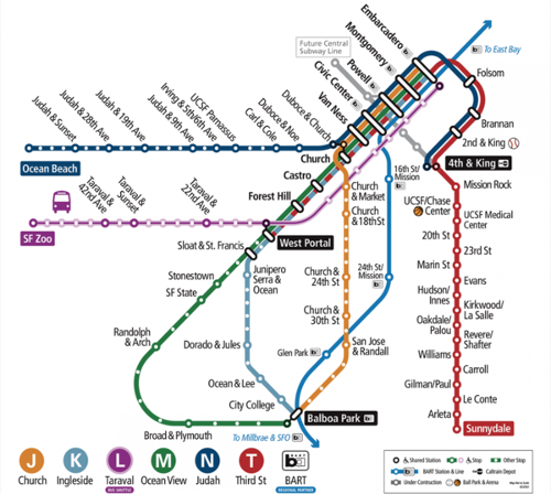
Inbound means J cars going toward Embarcadero Station. Outbound means J cars going toward Balboa Park.
From Balboa Park, the J line runs on surface to Duboce and Church, and operates in the subway under Market Street to Downtown San Francisco.
Stop list
Stops with a smaller dot are not wheelchair accessible.
<simpletable sep=comma cellspacing=0 cellpadding=0>
align=right| Station/stop names, , Points of interest/connections
align=right| Embarcadero Station, ![]() ,
align=right| Montgomery Station,
,
align=right| Montgomery Station, ![]() , Downtown San Francisco
align=right| Powell Station,
, Downtown San Francisco
align=right| Powell Station, ![]() , Union Square
align=right| Civic Center Station,
, Union Square
align=right| Civic Center Station, ![]() , Civic Center
align=right| Van Ness Station,
, Civic Center
align=right| Van Ness Station, ![]() ,
align=right| Subway portal,
,
align=right| Subway portal, ![]() ,
align=right| Church & Duboce,
,
align=right| Church & Duboce, ![]() , Outbound stop only for ADA/ramp users
align=right| Church & 14th/Market,
, Outbound stop only for ADA/ramp users
align=right| Church & 14th/Market, ![]() , Above Church Station
align=right| Church & 16th,
, Above Church Station
align=right| Church & 16th, ![]() , Mission Dolores
align=right| Church & 18th,
, Mission Dolores
align=right| Church & 18th, ![]() , Mission High School
align=right| ,
, Mission High School
align=right| , ![]() , On Private right of way
align=right| Right Of Way & 20th,
, On Private right of way
align=right| Right Of Way & 20th, ![]() , Mission Dolores Park
align=right| Right Of Way & Liberty,
, Mission Dolores Park
align=right| Right Of Way & Liberty, ![]() align=right| Right Of Way & 21st,
align=right| Right Of Way & 21st, ![]() align=right| ,
align=right| , ![]() , Back on Church St
align=right| Church & 22nd,
, Back on Church St
align=right| Church & 22nd, ![]() align=right| Church & 24th,
align=right| Church & 24th, ![]() , 24th Street (Noe Valley)
align=right| Church & Clipper,
, 24th Street (Noe Valley)
align=right| Church & Clipper, ![]() align=right| Church & 27th,
align=right| Church & 27th, ![]() align=right| Church & Day,
align=right| Church & Day, ![]() , Inbound stop only for ADA/ramp users
align=right| Church & 30th,
, Inbound stop only for ADA/ramp users
align=right| Church & 30th, ![]() align=right| 30th & Dolores,
align=right| 30th & Dolores, ![]() , 30th & Mission
align=right| San Jose & Randall,
, 30th & Mission
align=right| San Jose & Randall, ![]() align=right| Glen Park Station,
align=right| Glen Park Station, ![]() , BART
align=right| San Jose & Santa Rosa,
, BART
align=right| San Jose & Santa Rosa, ![]() align=right| San Jose & Santa Ynez,
align=right| San Jose & Santa Ynez, ![]() align=right| San Jose & Ocean,
align=right| San Jose & Ocean, ![]() align=right| San Jose & Geneva,
align=right| San Jose & Geneva, ![]() align=right| Balboa Park Station,
align=right| Balboa Park Station, ![]() , BART
</simpletable>
, BART
</simpletable>

